BACKGROUND MOTIVATION
Over the past decades, there has been a dramatic rise in disasters, and their impact on human populations. Rapid climate change has brought changing weather patterns, making risks increasingly challenging to predict and changing the ways in which hazards interact with each other. In 2010, disasters left over 300,000 people dead, affected another 220 million and caused over $US120 billion in economic damages.
That number reached $US366 billion in 2011. Europe’s Copernicus/Global Monitoring for Environment and Security (COPERNICUS/GMES) Programme is implementing a number of services related to climate change and to emergency management. In this last arena, COPERNICUS/GMES now offers both rush and non-rush operational mapping products for authorised users on a global basis. There is to date however no tool to integrate these diverse products and existing background data in a single work environment that supports the generation of new risk information.
PROJECT ABSTRACT
The Rapid Analysis and Spatialisation and Of Risk (RASOR) project will develop a platform to perform multi-hazard risk analysis to support the full cycle of disaster management, including targeted support to critical infrastructure monitoring and climate change impact assessment. RASOR adapts the newly developed 12m resolution TanDEM-X Digital Elevation Model (DEM) to risk management applications, using it as a base layer to interrogate data sets and develop specific disaster scenarios. RASOR overlays archived and near-real time very-high resolution optical and radar satellite data, combined with in-situ data for both global and local applications. Initially, RASOR will be available over five case study areas. Ultimately, the RASOR Consortium will offer global services to support in-depth risk assessment and full-cycle risk management.
RASOR uses a scenario-driven query system to allow users to simulate future scenarios based on existing and assumed conditions, to compare with historical scenarios, and to model multi-hazard risk both before and during an event. Managers can, for example, determine the extent of flooding in a given area and assess risk to Critical Infrastructure Systems in terms of the residual functionality of a given system (e.g. energy, transport, health). Public authorities can determine the potential impact of sea surge scenarios based on actual, accurate subsidence and its effect on flood defence infrastructure. RASOR allows managers to use real scenarios when determining new mitigation or prevention measures, and integrate new, real-time data into their operational systems during response activities.
RASOR ARCHITECTURE OVERVIEW
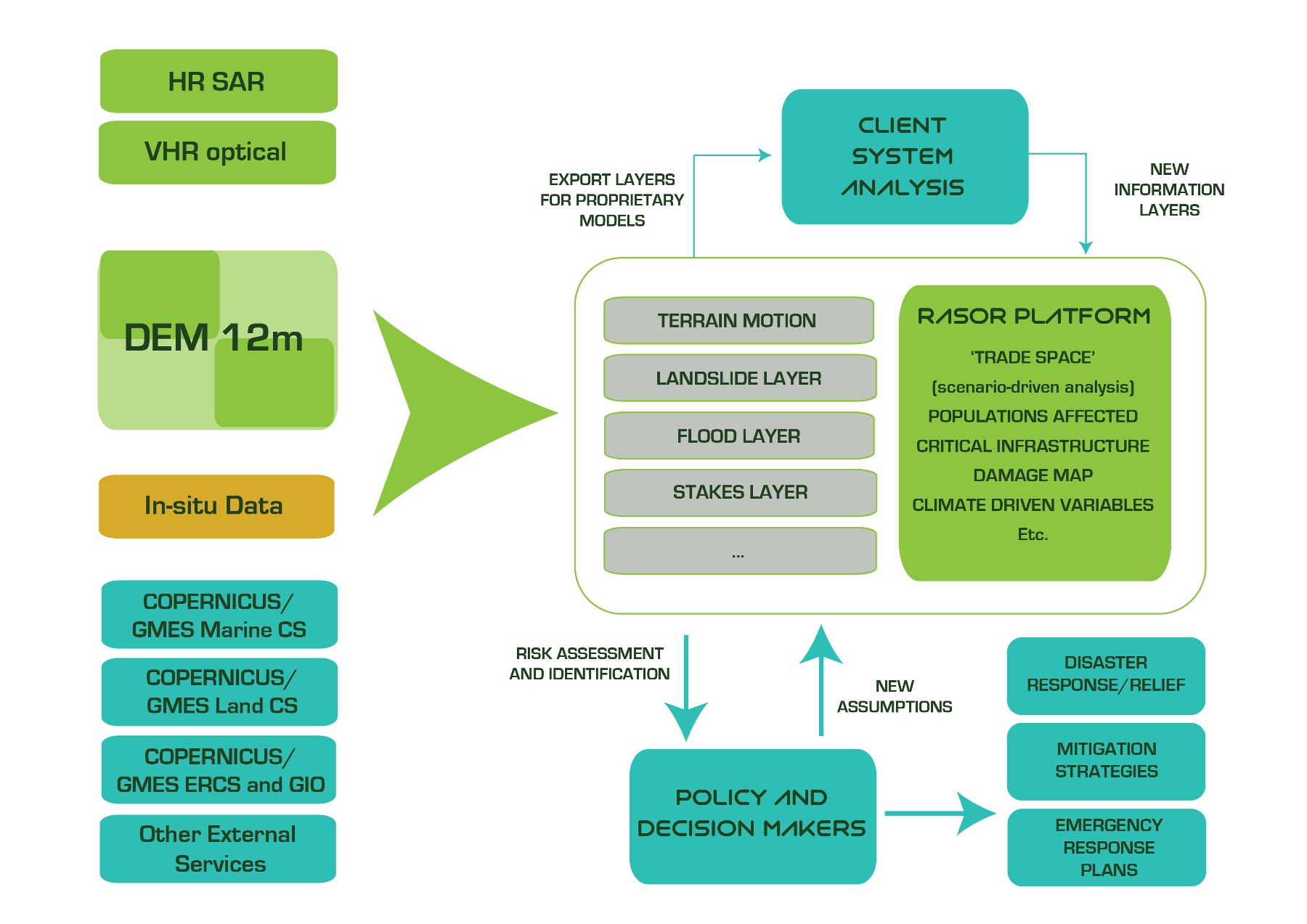
RASOR offers users the possibility to input variables (e.g. predicted rainfall, new tremors) and simulate likely scenarios to support risk mitigation measures. Only a project such as RASOR will enable the integration of so many diverse technology tools, by investing in adaptation of the TanDEM-X DTM to the specific technical issues (e.g. water flattening) that risk managers will face in applying the DTM to disasters, and ensuring seamless compatibility when various data layers are integrated into the platform. The result is a tool for fast and reliable multi-hazard risk assessment, applicable to several natural hazards worldwide and fit for usage in all phases of the disaster management cycle.
The services offered by RASOR tools will be able to produce detailed and accurate risk information within minutes of computing time, either as stand alone remotely-sourced analysis, or through the merging of satellite EO and detailed in-situ data sets, according to the needs of the client or end user. This is achieved by investing in the convergence of the latest generation of satellite data and related technology. Technologies able to reach higher levels of accuracy than ever before have become available, but have yet to be applied in a comprehensive manner to address risk assessment.
SERVICES DELIVERY AND SCOPE
The RASOR Consortium will offer three tracks of services based on adding value through customised exploitation of the RASOR tool for risk management and insurance markets: a global risk assessment service, and SME-led national and local services through innovative partnering arrangements in each national marketplace.
These tracks are validated in five different geographic locations (Haiti, Indonesia, Italy, Netherlands and Greece) with end users and practitioners, as well as with international organisations representing three different markets (World Bank for developing country and global analysis markets; UNOSAT for UN Agencies; Munich Re and RMS for insurance markets; and the European Commission’s agencies interested in risk management issues).
End users have been involved in conceiving the RASOR tool, and will shape its ultimate outcome through the in-depth development of requirements, a User Workshop and a dedicated Service Validation activity and Service Level Agreements (SLA) that demonstrate the viability of a commercial RASOR service to be offered at the conclusion of the project.
RASOR Coordinator: roberto.rudari@cimafoundation.org
RASOR Project Manager: andrew.eddy@athenaglobal.com
PROJECT DETAILS
End date: 1 June 2016
Total budget: 3.216.916€
EU funded contribution: 2.459.756€