


PROJECT ABSTRACT
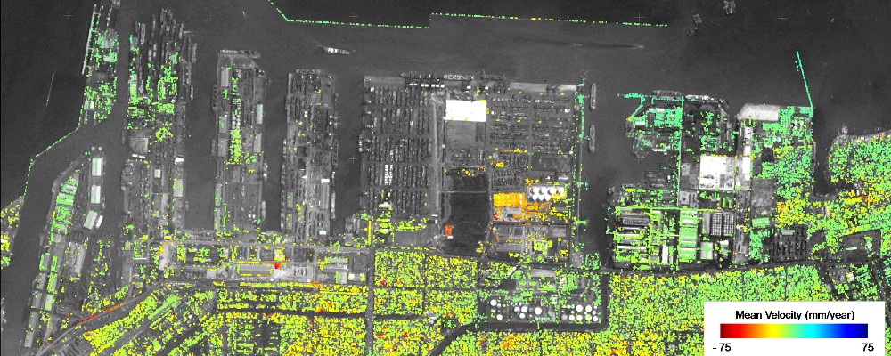
The Rapid Analysis and Spatialisation Of Risk (RASOR) project will develop a platform to perform multi-hazard risk analysis to support the full cycle of disaster management, including targeted support to critical infrastructure monitoring and climate change impact assessment. RASOR adapts the newly developed 12m resolution TanDEM-X Digital Elevation Model (DEM) to risk management applications, using it as a base layer to interrogate data sets and develop specific disaster scenarios. RASOR overlays archived and near-real time very-high resolution optical and radar satellite data, combined with in-situ data for both global and local applications. Initially, RASOR will be available over five case study areas. Ultimately, the RASOR Consortium will offer global services to support in-depth risk assessment and full-cycle risk management.
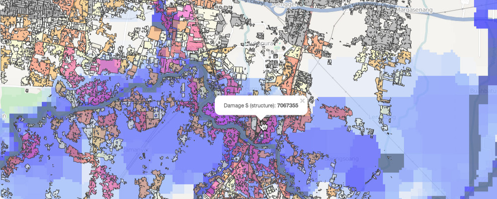
RASOR uses a scenario-driven query system to allow users to simulate future scenarios based on existing and assumed conditions, to compare with historical scenarios, and to model multi-hazard risk both before and during an event. Managers can, for example, determine the extent of flooding in a given area and assess risk to Critical Infrastructure Systems in terms of the residual functionality of a given system (e.g. energy, transport, health). Public authorities can determine the potential impact of sea surge scenarios based on actual, accurate subsidence and its effect on flood defence infrastructure. RASOR allows managers to use real scenarios when determining new mitigation or prevention measures, and integrate new, real-time data into their operational systems during response activities.
News
RASOR @CHy-15 – WMO, ASI-ISPRA-DPC side Event
Applications of the RASOR platform are presented at a side event of the WMO
RASOR&DRIHM in support of the Disaster assessment of Hurricane Matthew (Haiti)
RASOR and DRIHM platform combine to support modelling of the impact caused by Hurricane
RASOR Supports CNIGS and activities in Haiti in the wake of Matthew
RASOR is supporting the humanitarian actions in Haiti that has been struck by the
RASOR EC WS in Brussels 9th June 2016
RASOR Project will presented in a information Workshop next Thursday (9th June 2016) to
RASOR @CUF
RASOR Project presented at the 10th Copernicus User Forum in Brussels. The RASOR platform
RASOR Session @EGU2016
RASOR Contributions will be presented in a PICO (http://egu2016.eu/pico.html) session at EGU 2016 in
PROJECT DETAILS
End date: 1 June 2016
Total budget: 3.216.916€
EU funded contribution: 2.459.756€


Spotlight


Science & Tecnology 06/2016
WCDRR: Rapid Analysis and Spatialisation of Risk (RASOR), Lauro Rossi